Funded Projects

City Council has approved funding for the eleven projects described below.

Characterizing the Stormwater Runoff to Ground Water Quality Connection in the Recharge Zone of the Edwards Aquifer, Bexar, County, TX

Characterizing the Stormwater Runoff to Ground Water Quality Connection in the Recharge Zone of the Edwards Aquifer, Bexar, County, TX

Funding Recipient

USGS (US Geological Survey)

Description

The U.S. Geological Survey will conduct a study on characterizing the Stormwater Runoff to Groundwater Quality Connection in the Recharge Zone of the Edwards Aquifer, Bexar County, TX.

Total Funded

$432,000

Justification for Project

Historically, studies on the Edwards Aquifer have collected data on either groundwater or stormwater runoff, but not both within the same study.  A water quality network connecting stormwater runoff and groundwater quality provides the specific data needed to understand how development on the recharge zone in Bexar County is influencing water quality in the Edwards Aquifer.

Summary of Deliverables

  • Paired surface and ground water monitors installed in two locations and monitoring results analyzed
  • USGS Scientific Investigations Report
  • USGS Fact Sheet for the general public
  • Educational plaques

Project Objectives

Develop a better understanding of the connection between contaminants in stormwater runoff (surface water) and the water quality in the Edwards Aquifer. This scientific study will improve our conceptual model of how the aquifer system works. In addition, the study will provide new data that will be important for calibrating potential future computer models that are used to simulate “what if” scenarios.

Method

The project will install water quality sampling equipment at two stormwater runoff sites and corresponding downstream shallow groundwater wells nearby in the urbanized Recharge Zone to characterize water quality and the connection between surface water and ground water, with one runoff/well site pair established with previously sampled locations to leverage historical datasets, and the other pair installed where BMPs are not being actively implemented; conduct continuous monitoring, routine discrete sampling, and storm event sampling; review, analyze, interpret, archive, and publish the findings in a USGS Scientific Investigation Report and Fact Sheet; equip each site with education outreach plaques regarding Edwards sensitivity and project goals.

Consultants & Contractors

This project is not utilizing consultants or contractors.

Evaluation of Wastewater Disposal in the Recharge and Contributing Zones of the Edwards Aquifer Using a Coupled Surface-Water/Groundwater Model

Evaluation of Wastewater Disposal in the Recharge and Contributing Zones of the Edwards Aquifer Using a Coupled Surface-Water/Groundwater Model

Funding Recipient

SWRI (Southwest Research Institute)

Description

This project will develop a coupled surface-water/groundwater model that accurately simulates solute transport from on-site sewage facilities (OSSF) or Texas Land Application Permit (TLAP) wastewater disposal in the Edwards Contributing Zone and that quantifies the impact of solute transport on recharge to the Edwards Aquifer, including the impact of residential land-use development on surface-water and groundwater quality.

Total Funded

$530,398

Justification for Project

A critical but as yet unanswered question concerns what method of wastewater disposal imposes the greatest impact on the water recharging the Edwards Aquifer:  wastewater disposal using individual OSSF or wastewater disposal by TLAP.  Understanding the impact of wastewater disposal practices will provide a valuable tool when targeting areas within the Contributing and Recharge zones of the Edwards Aquifer that are most vulnerable to degradation from development.

Summary of Deliverables

  • Literature review on the selected watershed
  • Data assembly (hydraulic, water quality, flow, etc.)
  • Models
    • Hydrostratigraphic framework model
    • Surface-water model
    • Groundwater model
    • Solute-transport model
  • Simulation of solute transport using coupled models
  • Compilation and reporting of results

Project Objectives

  • Determine whether wastewater disposed by OSSF or TLAP facilities results in greater or lesser impact on water recharged to the Edwards.
  • Address whether areas located in the upland regions of watersheds within the Contributing Zone should be targeted by the EAPP as candidates for conservation easements or purchase to protect water quality and quantity that recharges the Edwards.
  • More accurately quantify the impact of development on the Recharge and Contributing zones.
  • Address specific threats including the impact of development that occurs too close to rivers, either in the Recharge or Contributing zone, and development that occurs in the Contributing Zone too close to the Recharge Zone.
  • Allow for accurate assessment of minimum distances from rivers and from the Recharge Zone that development (i.e., additional OSSF or TLAP) facilities would be deemed to not pose a threat to the quality and quantity of Edwards recharge.

Method

  • Development of and simulations using an integrated surface-water/groundwater model capable of simulating solute transport and surface-water/groundwater flow between aquifers
  • Development of and simulations using surface-water flow model to simulate solute transport in the selected watershed.

Consultants & Contractors

Aerotech, Edwards Aquifer Authority, City of Austin

Implementation of a Low Impact Development Test Bed at The University of Texas at San Antonio (UTSA) Main Campus)

Implementation of a Low Impact Development Test Bed at The University of Texas at San Antonio Main Campus

Funding Recipient

UTSA (University of Texas at San Antonio)

Description

Implementation of a Low Impact Development Test Bed at the UTSA Main Campus.

Total Funded

$1,069,113

Justification for Project

Low Impact Development (LID) is a strategy to mitigate the impacts of urbanization on Edwards Aquifer water quality.  Even though LID features, such as bioretention and sand filters, can enhance significantly the quality of urban stormwater, there are still barriers to its widespread use in new and retrofitted urban environments.  The barriers are technical, economical, educational, and regulatory.  This project will answer four main questions for our region related to the barriers:

  • What are the water quality differences between treating stormwater with sand filters and bioretention basins?
  • What are the water quality differences between treating stormwater with and without liners?
  • How much recharge can be generated in an unlined LID feature?
  • What is the best design for bioretention basins in terms of soils and plants for the San Antonio region?

Summary of Deliverables

  • Pilot tests on up to 13 bioretention soil columns and various native plant configurations.
  • Implement sand filter and bioretention basins on UTSA Campus .
  • Report on results of study to test features’ effectiveness for total suspended solids, nitrogen, phosphorus, metals, pH, conductivity and dissolved oxygen.
  •  Tours of features for K-12 education; implementation of LID into college course modules.

Project Objectives

Provide regulatory agencies information about benefits and risks of LID features through investigation of the liner requirement, differences between sand filter and bioretention treatments, and optimal combination of soil types and plants in bioretention for the San Antonio region through construction of LID test beds at UTSA Main Campus.

Method

The project will perform pre-LID construction stormwater monitoring at the future site of a constructed LID feature on UTSA’s Main Campus (currently not treated by any stormwater method), will conduct pilot-scale studies to identify the optimal combination of soil media and plants in bioretention columns, will implement the two best performing test column combinations in constructed bioretention cells without liners, will monitor post-construction stormwater runoff for two years, and will compare the results to stormwater monitoring samples collected from a control scenario consisting of a commonly-used lined sand filter.  Project will also develop a water sustainability and LID module for the undergraduate sophomore course Environmental Engineering and the senior Water Resources Engineering course and will provide tours of the project to low income K-12 student to boost interest of underrepresented students in STEM disciplines.

Consultants & Contractors

MTR Engineering, Mission 1 Contractors

Proposal for Stormwater Retrofit and Research Project

Proposal for Stormwater Retrofit and Research Project

Funding Recipient

GEAA (Greater Edwards Aquifer Alliance)

Description

The Greater Edwards Aquifer Alliance and Tetra Tech, in collaboration with the Lorence Creek HOA and the Shadow Cliff Swim and Tennis Club, will retrofit a residential stormwater drainage easement to include a vegetated swale and a bioretention facility and will conduct pre- and post-construction stormwater runoff water quality monitoring.

Total Funded

$351,474

Justification for Project

The project will improve water quality in the Edwards Aquifer Recharge Zone, generate critical data to characterize pollutant loadings from San Antonio neighborhoods, and promote infiltration into the Recharge Zone.

Summary of Deliverables

  • Pre- and post-construction stormwater runoff water quality data
  • Constructed stormwater control measures (SCM) consisting of a vegetated swale and bioretention facility
  • SCM Education outreach to homeowners, students, and volunteers participating in the project
  • Volunteer participation in SCM implementation and maintenance, including watering and plant replacement for two years.

Project Objectives

Improvement of water quality in the Edwards Aquifer Recharge Zone, contribution of water quality data for future studies, and homeowner association/volunteer participation in implementing and maintaining SCMs.

Method

  • The treatment train will be constructed to have two pre-treatment components:  1) a forebay to detain sediment, trash and debris; to prolong the lifespan of the bioretention facility; and to provide a sediment collection point for metals sampling, and 2) downstream of the forebay, the existing earthen channel will be reshaped and maintained as a vegetated swale to carry stormwater to the bioretention facility in a non-erosive manner and to filter sediment and collect any floatable debris that was carried past the forebay.  A new diversion structure will control the flow rate into the bioretention facility and ensure that large storm overflow bypasses the bioretention facility to prolong its life.
  • Monitoring will be via grab samples at the forebay, at the lowflow diversion structure, and where the stormwater exits the bioretention facility.
  • Maintenance and new native plant watering will be performed by trained volunteers.
  • The Greater Edwards Aquifer Alliance will conduct public and education outreach.

Consultants & Contractors

Tetra Tech, Alamo Analytics

Roof Top Harvesting and Stormwater Disbursement over the Edwards Aquifer Recharge Zone: A Retrofit for Previously Untreated Impervious Cover

Roof Top Harvesting and Stormwater Disbursement over the Edwards Aquifer Recharge Zone:  A Retrofit for Previously Untreated Impervious Cover

Funding Recipient

UTSA (University of Texas at San Antonio)

Description

The project will retrofit rooftops, parking lots, roadways, and sidewalks at UTSA Main Campus through diversion of stormwater runoff into a newly constructed suite of connected projects including cisterns, pervious pavement, a vegetated bioswale and forebay, a rain garden, and a bioretention and sand filtration area.

Total Funding

$1,057,401

Justification for the Project

The original design of the Main Campus called for stormwater to be conveyed away from the property through a system of storm drains and open swales that ultimately outfall into Leon Creek.  The original campus development pre-dates current regulatory compliance for water quality and impervious cover treatment and is considered Previously Untreated Impervious Cover (PUIC), which does not require treatment.  Originally 108 acres of the original campus is PUIC, including the area to be treated through this project.

Summary of Deliverables

  • Construction of above-listed LID features and development of LID BMP maintenance plan
  • Pre- and post-construction stormwater monitoring
  • BMP business plan with cost analysis that can be adopted for other entities
  • Educational signage and outdoor LID classroom/lab

Project Objectives

  • Bring the project area into compliance with today’s standards through highly visible LID features
  • Monitor the efficacy of LID features and their ability to remove solids and pollutants, reduce heat, and provide aesthetic alternative stormwater treatments.
  • Develop a cost analysis of the BMPs.
  • Provide educational signage and outdoor classroom.
  • Capture Edwards water on-site from rooftops and utilize it vs. an irrigation system for irrigation

Method

  • LID features are to be constructed in the Master Planned green space area called the East Lawn and Paseo Principal, which already has dedicated maintenance staff assigned to it.
  • The Paseo is a highly-trafficked area leading to the Convocation Center and the UC events venue housing ballrooms, meeting spaces, and food vendors.  Maintenance of the BMPs will reflect its importance.
  • The Quality Assurance Plan will be a collaborative effort between UTSA Facilities and the Department of Environmental Science and Ecology.
  • Prior to construction, sampling equipment will be installed to assess rainfall, stormflow at inflows and outflows of current treatment areas, and pollutant load of several constituents.
  • After construction, stormwater sampling will continue for at least 5 stormwater events in order to assess new treatment effectiveness

Consultants & Contractors

None to date. Still in procurement for design firm.

Tracking the Primary Sources of Fecal Pollution in the Recharge and Contributing Zones of Edwards Aquifer in Bexar County, Texas, Using Molecular Tools

Tracking the Primary Sources of Fecal Pollution in the Recharge and Contributing Zones of Edwards Aquifer in Bexar County, Texas, Using Molecular Tools

Funding Recipient

UTSA (University of Texas at San Antonio)

Description

The University of Texas at San Antonio Department of Civil and Environmental Engineering will design and implement an efficient fecal source tracking and evaluation program, specifically identifying potential fecal sources such as municipal waste/runoff and animal waste as well as other contributing factors.

Total Funding

$692,452

Justification for the Project

Identifying the types of sources that contribute to bacteria in water systems is key when developing strategies to reduce bacteria and other pollution levels in surface water and groundwater and when evaluating their potential impact on the environment.  In a karst region where sources are not easily known or understood, microbial source tracking techniques can provide an opportunity to analyze water samples in a way that identifies the source of fecal bacteria in the sample, from simply identifying whether the source is human or non-human to, at times, identifying the source to the species level (e.g., cow, dog, deer).

Summary of Deliverables

  • Monitoring datasets, publication of results in peer reviewed journals, curriculum materials, verbal and written social and traditional media materials, metadata (water quality)
  • Spatial and temporal maps of fecal sources
  • Education and public outreach activities regarding non-point source pollution sources
  • Homeowner education modules and UTSA Civil & Environmental Engineering Department course work on septic tanks, domestic pet waste, urban wildlife populations, household wells.

Project Objectives

  • Identify the presence and predominant sources of pathogenic fecal bacteria, such as municipal waste/runoff and animal waste
  • Evaluate fecal microbial input into Aquifer water from the recharge and contributing zones and which sources are controllable
  • Assess microbial impact on water quality, human health, and the environment.

Method

  • Bi-weekly sampling for a 24-month period, varied by season and intensity, at 20 sampling points consisting of springs, wells, river and creek sites within the Edwards’ Recharge and Contributing zones.  Storm-related sampling will include multi-day samples before, during and after storm events and daily samples leading up to and after the event to determine peak loadings.  Summer sampling will increase in frequency.
  • Use of microbial source tracking (MST) to identify the origin of fecal contamination by targeting the Bacteroidales 16S rRNA genes, which can be linked with good spatio-temporal resolution to a sampling site.
  • The first molecular approach to studying pathogenic fecal contaminants in the Edwards, specifically using Polymerase Chain Reaction (PCR) and qPCR (Quantitative PCR) molecular techniques to identify and distinguish between human and animal fecal bacteria.
  • Water quality parameters will be performed at every monitoring site:  pH, temperature, dissolved oxygen, dissolved nitrogen.
  • PCR-based assays will be performed in the Kapoor Lab at UTSA using EPA issued Quality Assurance/Quality Control (QAQC) guidance.  Select samples will be analyzed for Bacteria Source Tracking validation.

Consultants & Contractors

This project is not utilizing consultants or contractors.

Water Quality in the Leon Creek Watershed Recharge Zone as a Function of Urban Development, and Community Education of the Threats and Conservation of the Edwards Aquifer

Water Quality in the Leon Creek Watershed Recharge Zone as a Function of Urban Development, and Community Education of the Threats and Conservation of the Edwards Aquifer

Description

This University of Texas at San Antonio project has three major components:

  • Goal 1, Describing the Water Quality as a Function of Land Cover within the Edwards Aquifer Recharge Zone in Bexar County:

An assessment of water quality as a function of land cover at eight sampling sites, which will collect and analyze 864 stormwater samples within the Leon Creek Watershed from January 2019 to September 2021, assess the physical stream habitat at the eight locations, and develop a report on the above.

  • Goal 2, Describing the Efficacy of Low Impact Developments on Water Quality:

A study of the efficacy of low impact development on water quality, which will install six sampling sites to allow for comparison of water quality related to Low Impact Development best management practices (LID BMPs) associated with the new separately-funded UTSA parking lot, collect and sample 648 post-construction samples from January 2019 – 2021, and develop report on the above.

  • Goal 3, Community Outreach and the Development of a Living Laboratory:  

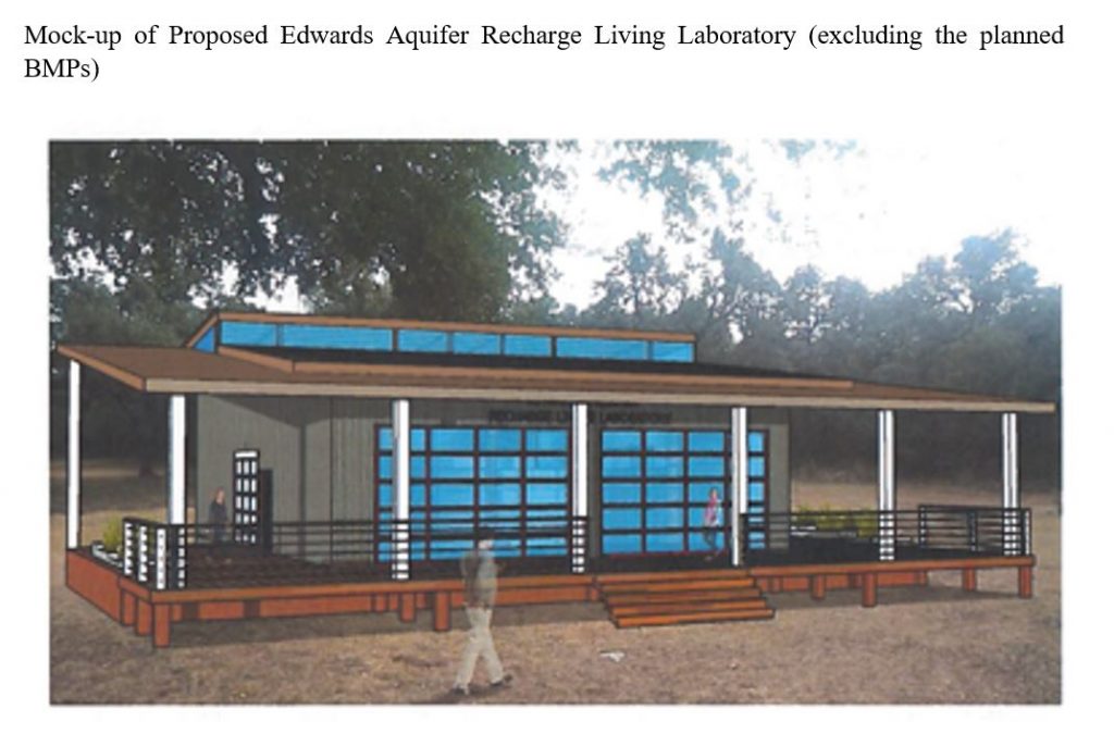
Community outreach through construction and furnishing of the Edwards Aquifer Recharge Living Laboratory, restriping of an existing parking lot to add ADA spaces, construction of BMPs for the Laboratory facility, construction of an amphitheater, walking trails, and bird-watching screens, and an assessment of and report on the implementation cost of the Laboratory’s BMPs, the long-term BMP maintenance, and the energy cost using a green roof.  In exchange, at UTSA’s sole cost, UTSA will operate and maintain the Laboratory for a minimum of 25 years.

Total Funded

The City will contribute $2,671,236 for the Project.  The San Antonio River Authority will reimburse the Funding Recipient up to an additional $12,000 for monitoring components of the project.

Justification for Project

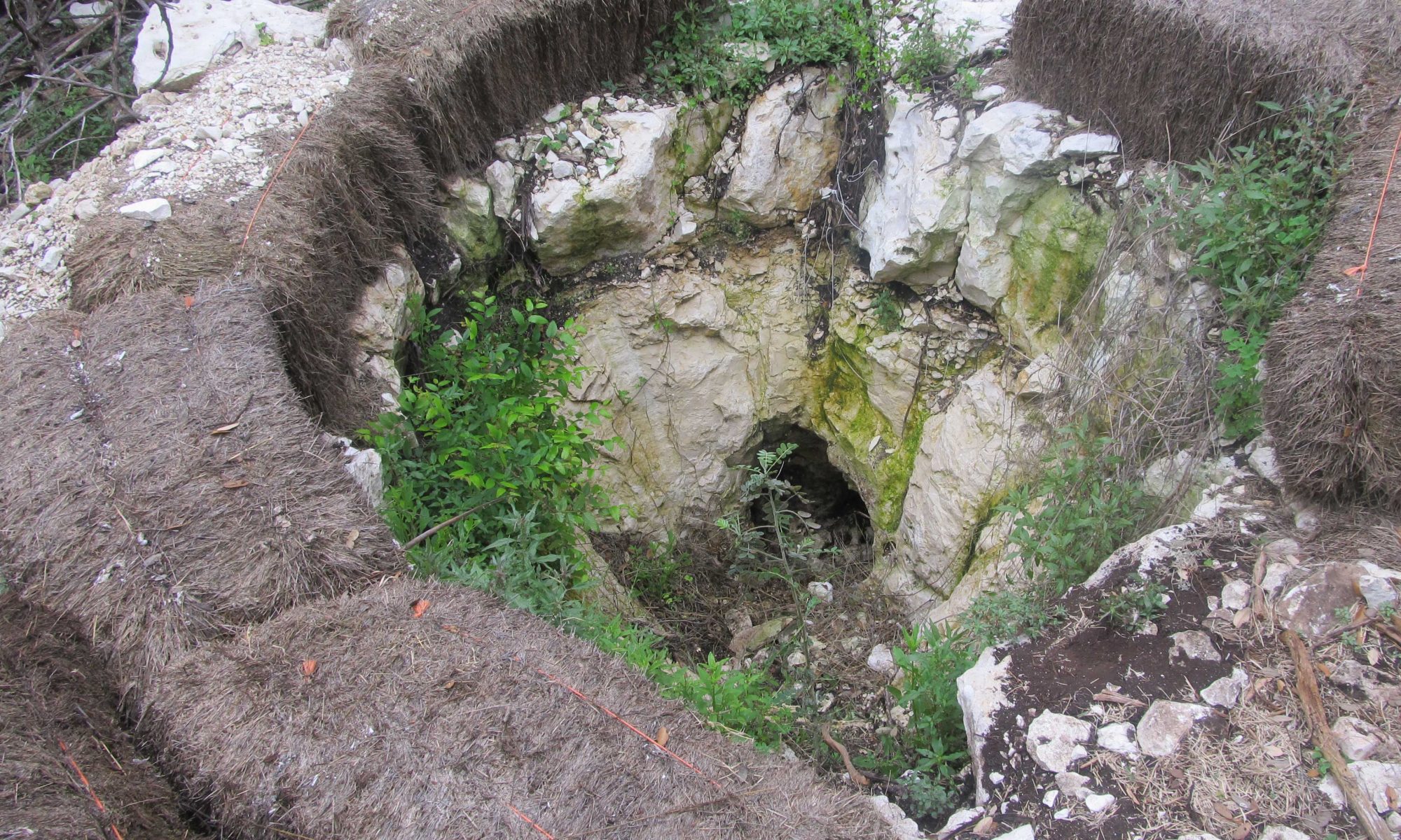
  • Goal 1 focuses on one of the fastest growing areas in Bexar County.  The Leon Creek watershed in northern Bexar County is an urbanizing watershed with on-going development occurring in currently forested and low-density urban areas.  Very little is known about how water quality is impacted by changes in land cover from forested areas of Ashe juniper to areas of urban development.
  • Goal 2 leverages a UTSA-funded development project (new parking lot) which is incorporating LID BMPs to assess the effects of these BMPs on water quality.  In spite of the general understanding that BMPs improve water quality, the applicants could find no literature showing the effects of BMPs on water quality and quantity within the Edwards Aquifer Recharge Zone.  
  • Goal 3 leverages existing outreach programs and formal partnerships with the US Forest Service and the US Fish and Wildlife Service and informal partnerships with other area entities to expand the University’s outreach to include the Edwards Aquifer.  It has been shown that individuals who participate in water-related education programs build a “water conscience.”  This component of the program will construct the Edwards Aquifer Recharge Living Laboratory where UTSA will deliver curriculum on Bexar County’s water use, water conservation, and water quality.

Summary of Deliverables

Goal 1:

  • Baseline data on water quality in the mostly undeveloped Leon Creek watershed.
  • Installation of eight stormwater monitoring sites, four in non-developed areas and four in developed areas within Leon Creek watershed.
  • Collection and analysis of stormwater samples.
  • Stormwater monitoring data.
  • Measurement of the physical stream habitat parameters at each of the eight locations.
  • Report on the above.

Goal 2:

  • Installation of six sampling sites, to allow for comparison of water quality related to three BMPs associated with the UTSA-funded parking lot:  bioswales, vegetative filter strip, and sand filter.
  • Collection and analysis of post-construction stormwater samples, including “first flush” and variously throughout each storm event.
  • Post-construction stormwater monitoring data.
  • Report on the above.

Goal 3:

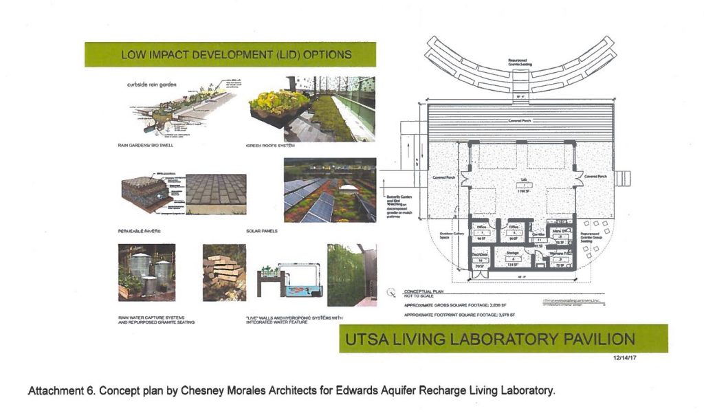
  • Construction of a 2,000 ft2 structure with a wrap-around porch to serve as the Edwards Aquifer Recharge Living Laboratory.  The site will feature
    • Bioswale, rain garden, roof-top rain collection and cistern, tree boxes attached to stormwater boxes, green roof.  (All infiltrative BMPs will have an impermeable liner.)  The BMPs will be sized to capture an existing watershed that is 70% impervious cover, drains to Maverick Creek, and predates TCEQ rules.
    • Walking trails, bird-watching screens, and an amphitheater which will reuse pink granite benches from the Institute of Texas Cultures.
    • Installation of sampling sites to measure water quality for three years from project start.
    • Collection and analysis of post-construction stormwater monitoring data.
    • Weekly, monthly, and annual inspections of the BMPs.
    • Report on above sampling findings.
    • Staffing, coordination and tracking of use, operation, maintenance of the Living Laboratory to include offering K – 12 education for 25 years after the Proposition 1 funded project is complete.

Mock-up of Proposed Edwards Aquifer Recharge Living LaboratoryUTSA Living Laboratory Pavilion

Project Objectives

The Project will answer the following questions and/or address the following local deficits:

    • Water Quality as a Function of Land Cover:  What are the effects of dominant vegetation on water quality within the Edwards Aquifer Recharge and Contributing Zones, and what effect does the replacement of this cover with urban cover have on water quality?
    • Efficacy of LID on Water Quality:  What are the effects of LID BMPs on stormwater runoff from new parking lots?
    • Community Outreach/Living Laboratory:  The San Antonio/Bexar County region currently lacks a permanent facility dedicated to Edwards Aquifer conservation and water quality issues.

Other

    • Goal 1 will provide a unique comparison of water quality data—not urban with and urban without BMPs, but pre-development condition vs. urban with BMPs—to determine BMP efficacy in protecting degradation of water quality relative to existing water quality pre-development.
    • Construction of Edwards Aquifer Recharge Living Laboratory and its BMPs will begin after spring semester ends to minimize disruption to and by student activity.
    • Living Laboratory will be staffed by an existing full-time UTSA Office of Facilities employee.  
    • Demographics and numbers of visitors to the Edwards Aquifer Recharge Living Laboratory will be recorded.
    • Manuscripts addressing all three main project components will be created, and findings will be presented at local and national meetings.   
Edwards Aquifer Water Quality Protection from Catastrophic and Low to Mid-Level Effects of Discharge of Hazardous and Polluting Materials from Contaminated Water Runoff during Emergency Response

Edwards Aquifer Water Quality Protection from Catastrophic and Low to Mid-Level Effects of Discharge of Hazardous and Polluting Materials from Contaminated Water Runoff during Emergency Response

Description

This Texas A&M University – San Antonio project will eliminate or reduce risks of pollution discharge from occasional potentially catastrophic and low to mid-level effects of response to emergencies such as fire, flood, high wind, and explosion in structures and along transportation corridors in the Edwards Aquifer Recharge Zone in Bexar County by enabling and equipping First Responders with Best Management Practices (BMPs) and training, and by helping to reduce or eliminate impact to water quality from emergency response runoff during emergency events in locations where threats exist due to on-site storage, production, or transport exchanges of polluting or hazardous materials.

Total Funded

The City will contribute $218,937 for the Project.  The Funding Recipient will secure and provide $78,000 in in-kind contributions and $10,000 in annual management funding.

Justification for Project

In 2007 the Texas Legislature directed the Edwards Aquifer Authority to protect the water quality of the Edwards Aquifer from the impact of fire control in the Edwards Aquifer’s recharge zone.  The event that prompted legislative action was a fire called “Mulchie” that burned for three months in an eight-story high mulch and debris pile on the edge of the Edwards Aquifer recharge zone near Helotes. The legislative mandate covered reducing impacts on aquifer water quality of catastrophic and mid- to low-level pollution of the aquifer from day-to-day fire control activities in the presence of hazardous and other polluting materials in the recharge zone. The project will accomplish the mandate of the legislature to address both catastrophic and low- to mid-level pollution of the aquifer due to fire response, by leveraging multiple collaborators, funding sources, and in-kind contributions to address the deficiencies in current programs intended to protect the aquifer.

Summary of Deliverables

  1. Training curriculum, program, and educational materials for 12-hour, 2-day course for first responders on reducing or eliminating emergency runoff into the Edwards Aquifer recharge zone
  2. Delivery of said training course to first responders
  3. Emergency response BMPs tailored for the Edwards Aquifer recharge zone
  4. Evaluation of course curriculum, BMPs, and associated materials
  5. Edwards Aquifer Water Quality Protection Information Base and User-Friendly Interface for First Responders and Fire Emergencies providing essential guidance and site-specific information about recharge zone locations
  6. Emergency response BMP effectiveness assessment protocol
  7. Integration of assessment protocol into regular EAA sampling/monitoring programs
  8. Video providing first responders and public easily understood information about sensitivity of karst recharge zone and need for aquifer protection against hazardous materials during emergency response
  9. General outreach and education materials
  10. Workshop on emergency response experiences and practices in karst watersheds
  11. Workshop proceedings report
  12. Final project report.

Project Objectives

The Project will answer the following questions and/or address the following local deficits:

  • What are the new BMPs and/or new applications of existing BMPs necessary to protect the Edwards Aquifer recharge zone from emergency response-generated runoff?
  • What additional equipment is needed by first responders to control emergency response contaminated water runoff in the Edwards recharge zone?
  • What are the results of this Project in protecting the Edwards Aquifer recharge zone from catastrophic and low- to mid-level pollution due to fire response?
  • What similar programs and projects for emergency responders are underway in karst aquifers elsewhere?

Other

  • Parties supporting and/or collaborating with Texas A&M University – San Antonio in the implementation of this project include the Edwards Aquifer Authority, the Edwards Aquifer Conservancy, the City of San Antonio Fire Department, EcoCentro of the Alamo Colleges District, and Texas Parks and Wildlife Department.
Demonstrating the Environmental Benefits of Permeable Paved Surfaces over the Edwards Aquifer

Demonstrating the Environmental Benefits of Permeable Paved Surfaces over the Edwards Aquifer

Description

This UTSA project will demonstrate how permeable pavement designs can mitigate the water quality and amount of stormwater runoff associated with impermeable pavement surfaces over the Edwards Aquifer Recharge Zone and examine whether these alternative permeable pavement designs reduce pavement surface temperatures and water runoff temperatures, thus contributing to mitigating urban heat island effects.

Total Funded

$1,035,761.00

Justification for Project

In urban areas, replacing the natural land cover with impervious surfaces, including parking lots, increases pollutant concentration in runoff (Tong et al. 2009). Furthermore, urban drainage infrastructure removes excess runoff from the surface, which results in concentrated runoff volumes and faster and higher peak flows, which can cause downstream flooding, property damage and loss of life (Sharif et al. 2014, Fang et al., 2014). Conventional paved surfaces (e.g., roadways, walkways and parking areas) comprise a large fraction of the impermeable ground cover in Bexar County, which is estimated to be about 14.1% of its total area. The goal of this project is to demonstrate how four alternative permeable pavement designs mitigate stormwater runoff water quality and quantity compared to impermeable pavement surfaces over the Edwards Aquifer recharge zone. In addition, it will examine whether these alternative designs reduce pavement surface and water runoff temperatures and thus contribute in mitigating urban heat island (UHI) effects.

Summary of Deliverables

  1. A permeable pavement parking lot composed of four independent cells, each cell with eight parking stalls utilizing one of the four best management practices (BMPs) below, for a total of 32 parking stalls:
    1. Permeable Asphalt Concrete
    2. Plastic Grid Pavers
    3. Permeable Portland Concrete
    4. Permeable Interlocking Concrete Pavers
  2. Pre-, post-, and during construction stormwater analyses
  3. Quarterly routine maintenance of the four BMPs during the final year of the Project
  4. Economic analysis of the costs and benefits of the four BMPs compared to the adjacent 32 conventional parking stalls built by the City of San Antonio during this Project
  5. Design guidelines for the four BMPs for potential amendment to the San Antonio River Basin LID Design Guidance Manual
  6. Educational module demonstrating permeable pave benefits; to be incorporated into the UTSA Water Resources CE 4603 and Advanced Pavement Analysis CE 5423 courses.

Project Objectives

The Project will answer the following questions and/or address the following local deficits:

  1. How do the four BMPs compare against each other in addressing stormwater quality concerns? Stormwater quantity concerns?  Heat island effects?
  2. How do the four BMPs compare against the conventional parking lot in addressing stormwater quality concerns? Stormwater quantity concerns?  Heat island effects?
  3. What is the relative cost of building the four BMPs versus conventional lots?

Other

  • This project enhances the 2017-2022 Bond Proposition 3 Classen-Steubing Ranch recreational facility project and is being coordinated with the City of San Antonio Transportation and Capital Improvements Department and the Parks and Recreation Department.
  • After the project’s conclusion, the permeable pavement system ownership will be transferred to the City of San Antonio’s Parks and Recreation Department, which shall perform all maintenance actions henceforth.
Evaluation of the Vegetation along Roadways in Edwards Aquifer Recharge and Contributing Zones for Storm Water Management and Water Quality Improvement

Evaluation of the Vegetation along Roadways in Edwards Aquifer Recharge and Contributing Zones for Storm Water Management and Water Quality Improvement

Description

This UTSA project will evaluate soil and vegetation composition and density along roadways in the Edwards Recharge and Contributing Zones of Bexar County for control of sediments, nutrients, and other pollutants and make recommendations of xeric species of vegetation most adaptable to roadway conditions.

Total Funded

$798,636

Justification for Project

San Antonio experienced the highest per capita growth of any major city in 2017, and the population of Bexar County is estimated to reach 2.8 million by 2060 representing a 94% increase from 2000 to 2060 (TWDB,2011). Increased population is characterized by loss of natural habitat, fragmented ecosystems, and impacts to environmental processes and ecosystems services. Development and habitat fragmentation result not only in increased stormwater runoff, but also loss of ecosystem services and declines in biodiversity which can impact water quality (Vitousek 1994, Walsh 2000).  An increase in impervious surface, including roadways, is another factor that results from increased population growth and urbanization, with potential to impact the Edwards Aquifer.  In arid and semi-arid regions such as central Texas, understanding vegetation composition and coverage will provide insight into which species are most efficient in trapping sediment and removing pollutants from stormwater runoff along roadways.

Summary of Deliverables

  1. Quality Assurance Protection Plan (QAPP)
  2. Collection of minimum of 10 precipitation events flowing into each retention basin and swale for physical, biological, and chemical pollutants over 24 months
  3. Vegetation surveys
  4. Vegetation analysis and soil composition
  5. Microbial community analysis
  6. Vegetation greenhouse study
  7. Sediment deposition study
  8. Stormwater quality analysis
  9. Stormwater basin characteristics analysis
  10. Statistical analysis
  11. Public Outreach to Alamo Chapter of Master Naturalists, UTSA Environmental Science and Ecology Summer Camps, and through the UTSA Department of Environmental Science and Ecology Website with links to other information on best management practices along roadways and LID programs.
  12. Incorporation of study results into UTSA’s Water Pollution Control and Biological Phenomena in Environmental Engineering courses
  13. Final report.

Project Objectives

The Project will answer the following questions and/or address the following local deficits:

  1. What native vegetation can effectively remove nutrients and other pollutants along roadway vegetated buffers?
  2. What native evergreen and perennial vegetation is most efficient at surviving periods of droughts and short periods of inundation?
  3. What species are effective at trapping and slowing sediment and absorbing pollutants from stormwater runoff along roadways?
  4. What percent cover of native vegetation is required to retain 75% of the sediment from roadway runoff?
BMP Maintenance Requirements to Ensure Protection of Edwards Aquifer Water Quality

BMP Maintenance Requirements to Ensure Protection of Edwards Aquifer Water Quality

Funding Recipient

UTSA

Description

UTSA will execute a comprehensive water quality monitoring plan that assesses impacts of water quality Best Management Practices (BMP) maintenance on sand filters, cartridge filters, and hydrodynamic separators. The project will also monitor water quality during a minimum of five rain events before and five rain events after recommended maintenance.

Total Funded

$619,656

Justification for Project

On September 16, 2019, a facilitated workshop of the Edwards Aquifer Protection Venue Project, Water Quality Component, Stakeholder Advisory Committee and Technical Advisory Committee was held to assess contributions the funded projects portfolio was making toward water quality; to identify knowledge, policy, data, etc. gaps remaining; and to prioritize those gaps for potential future funding and/or resources.  The two advisory committees’ input reflected that more work needed to be done in the Edwards Contributing Zone (CZ), and the maintenance of water quality BMPs needed to be assessed and better understood.

Method

Methods of measuring, assessing, and reporting BMP maintenance effectiveness:  The project will use spatial data to classify BMPs for effective assessment and relationships among BMP compliance, BMP type, and the built environment; conduct database searches for permitted BMPs in the CZ; obtain and geocode TCEQ and SAWS data on BMPs with prior non-compliances; assess geographic factors (1. ag area, 2. built-up area, 3. high point, and 4. low point) correlating with compliance issues to better target policy decisions for current maintenance compliance trends.

Method by which project will measure water quality contribution, BMP reliability, and maintenance under variable conditions and over long term:  The project will perform a cost-benefit analysis for maintenance options for the monitored BMPs and assess whether maintenance timing impacts water quality.

Other Considerations

The project will consider how BMP functions differ in the CZ, the Recharge Zone, and the Transition Zone.

Consultants & Contractors

This project is not utilizing consultants or contractors.